
Citation: UNSPECIFIED.
![[thumbnail of installation]](http://researcharchive.wintec.ac.nz/252/4/absolute_divide_6.jpg)

absolute_divide_6.jpg - Published Version
Available under License Creative Commons Attribution Non-commercial Share Alike.
Download (140kB) | Preview
![[thumbnail of NZ Education Review Cover Story March 2008]](http://researcharchive.wintec.ac.nz/style/images/fileicons/application_pdf.png) PDF (NZ Education Review Cover Story March 2008)
PDF (NZ Education Review Cover Story March 2008)
NZER_1.pdf - Published Version
Download (320kB)
PDF (NZ Art Monthly feature article)
NZArtMonthly.pdf - Published Version
Download (678kB)
PDF (NZ Education Review Cover Story March 2008 (detail))
NZER_2.pdf - Published Version
Download (390kB)
Abstract
The Waitakaruru Arboretum and Sculpture Park is located on the Waikato-side of a border that separates the Waikato and Matamata-Piako district council areas. The arboretum can be found at the southern end of the Waikato/Matamata-Piako border. MÄ?ori first settled in the area in the early 1300's, although little is known today of the area's pre-colonial history. European missionaries arrived in the 1830's to establish the first missions. Traders then arrived in growing numbers during the 1850's, and the first permanent PÄ?kehÄ? settlements were established from 1865 following the MÄ?ori land wars and subsequent land confiscations, which resulted in large tracts of swamp being cleared by PÄ?kehÄ? for agricultural farming.
The original boundary line that separates the Waikato and Matamata/Piako Districts was first drawn in 1864 following the land wars, and was later used to determine the then new council boundaries in 1876 when the District Councils were first established. The boundary includes one particularly long perfectly straight line at about 10 degrees counter-clockwise from true north on the compass. This boundary line stretches for over 43kms from the Orakei Stream in the north to Pukemoremore Hill just south of the Waitakaruru Arboretum. The boundary line encompasses mainly farmland plus 3 roads along its path: Manuel Road, Valentine Road and Pukemoremore Road. Although not easily visible from the ground, the scale of this 43km long perfectly straight divide can be clearly seen from the air.
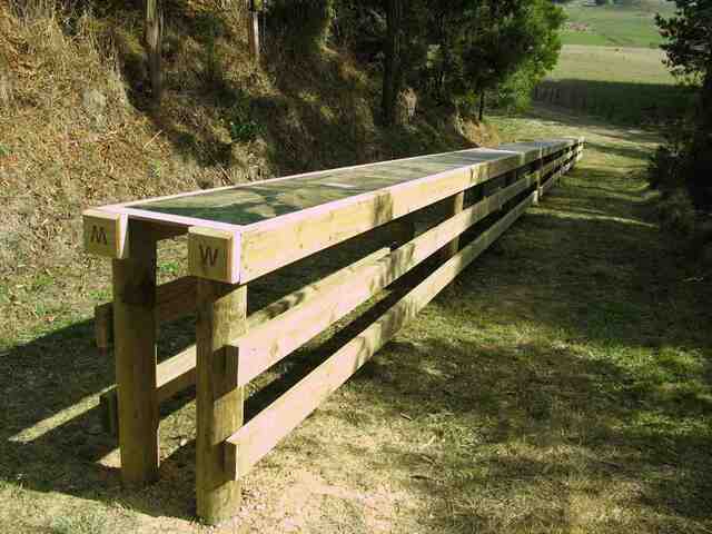
absolute divide reflects the artificial border or aukati that separates the Waikato and Matamata-Piako districts. Using locally produced timber for fencing, plus sheets of marine plywood for the image substrate, a series of 180 vertical aerial photographs have been digitally stitched together to make one long single image that has been printed directly onto plywood using the latest eco-printing technology. Governments and the military use vertical aerial photography for land surveying and human surveillance purposes. The entire structure comprises two 26-meter long perfectly straight parallel wooden split-rail farm fences located 600mm apart. The two post and rail fences support eleven 2,400mm plywood panels that, when aligned in a long row horizontally, present one long single photographic vertical aerial strip or line.
| Item Type: | Contribution to a Show/Exhibition |
|---|---|
| Additional Information: | Curated by Kim Patton |
| Uncontrolled Keywords: | Art Sculpture Installation Autaki Confiscation Line Waitakaruru Waikato Aerial Contemporary Sublime Phenomenology Absolute Ceiling Scale Perspective Space Time CK Reynolds CKReynolds New Zealand |
| Subjects: | N Fine Arts > N Visual arts (General) For photography, see TR G Geography. Anthropology. Recreation > G Geography (General) T Technology > TR Photography N Fine Arts > NB Sculpture D History General and Old World > DU Oceania (South Seas) |
| Divisions: | Corporate > Centre for Creative Industries |
| Depositing User: | Cheryl Reynolds |
| Date Deposited: | 09 Jul 2009 03:27 |
| Last Modified: | 21 Jul 2023 02:17 |
| URI: | http://researcharchive.wintec.ac.nz/id/eprint/252 |
Actions (login required)

- View Item